NGSIToCarto
Functionality
NGSIToCarto is a processor designed to persist NGSI-like context data within a PostgreSQL server to be read by Carto. These context data usually come from the Orion Context Broker instance , but could be any other system speaking the NGSI language.
Independently of the data generator, NGSI context data is always transformed into internal NGSIEvent objects at Draco
sources. In the end, the information within these events must be mapped into specific PostgreSQL data structures.
Mapping NGSI events to NGSIEvent objects
Notified NGSI events (containing context data) are transformed into NGSIEvent objects (for each context element a
NGSIEvent is created; such an event is a mix of certain headers and a ContextElement object), independently of the
NGSI data generator or the final backend where it is persisted.
This is done at the Draco-ngsi Http listeners (in Flume jergon, sources) thanks to
NGSIRestHandler. Once translated, the data (now, as NGSIEvent objects) is put into the
internal channels for future consumption (see next section).
Mapping NGSIEvents to PostgreSQL data structures
PostgreSQL organizes the data in schemas inside a database that contain tables of data rows. Such organization is
exploited by NGSIToPostgreSQL each time a NGSIEvent is going to be persisted.
PostgreSQL databases naming conventions
Previous to any operation with PostgreSQL you need to create the database to be used.
It must be said
PostgreSQL only accepts
alphanumeric characters and the underscore (_). This leads to certain encoding is applied depending
on the enable_encoding configuration parameter.
PostgreSQL databases name length is limited to 63 characters.
Also, because of a Carto's requirement, the name must begin with a letter (a-z).
PostgreSQL schemas naming conventions
A schema named as the notified fiware-service header value (or, in absence of such a header, the defaulted value for
the FIWARE service) is created (if not existing yet).
It must be said
PostgreSQL only accepts
alphanumeric characters and the underscore (_). This leads to certain encoding is applied depending
on the enable_encoding configuration parameter.
PostgreSQL schemas name length is limited to 63 characters.
Also, because of a Carto's requirement, the name must begin with a letter (a-z). Top
PostgreSQL tables naming conventions
The name of these tables depends on the configured data model (see the Configuration section for more details):
- Data model by service path (
data_model=dm-by-service-path). As the data model name denotes, the notified FIWARE service path (or the configured one as default inNGSIRestHandler) is used as the name of the table. This allows the data about all the NGSI entities belonging to the same service path is stored in this unique table. The only constraint regarding this data model is the FIWARE service path cannot be the root one (/). - Data model by entity (
data_model=dm-by-entity). For each entity, the notified/default FIWARE service path is concatenated to the notified entity ID and type in order to compose the table name. If the FIWARE service path is the root one (/) then only the entity ID and type are concatenated.
It must be said
PostgreSQL only accepts
alphanumeric characters and the underscore (_). This leads to certain encoding is applied depending
on the enable_encoding configuration parameter.
PostgreSQL tables name length is limited to 63 characters.
The following table summarizes the table name composition (old encoding):
| FIWARE service path | db-by-service-path |
db-by-entity |
|---|---|---|
/ |
N/A | <entityId>_<entityType> |
/<svcPath> |
<svcPath> |
<svcPath>_<entityId>_<entityType> |
Using the new encoding:
| FIWARE service path | db-by-service-path |
db-by-entity |
|---|---|---|
/ |
x002f |
x002fxffff<entityId>xffff<entityType> |
/<svcPath> |
x002f<svcPath> |
x002f<svcPath>xffff<entityId>xffff<entityType> |
Please observe the concatenation of entity ID and type is already given in the notified_entities/grouped_entities
header values (depending on using or not the grouping rules, see the Configuration section for more
details) within the NGSIEvent.
Raw-based storing
It must be enabled the enable_raw parameter, unless enable_distance is not activated, so enable_raw will be
enabled by default. It will have the following fields:
cartodb_id: This column is used as the primary key of the tableRecvTime: UTC timestamp in human-redable format (ISO 8601).RecvTimeTs: Timestamp in milliseconds.FiwareServicePath: Notified fiware-servicePath, or the default configured one if not notified.entityId: Notified entity identifier.entityType: Notified entity type.the_geom: Geo-localized point that contains the longitude and latitude, of PostGIS Geometry type. It use the reference sistem EPSG 4326. It must be created by means of the ST_Point () function. It can be of three types:geo:point: a point.geo:json: GeoJSON representing a point.
the_geom_webmercator:Exactly the same asthe_geombt changing the EPSH sistem reference to 3857.- For each not-geolocated attribute, the insert will contain two additional field, one named with the
attrNamereceived and another with the metadata.
Distance-based storing
It must be enabled the enable_distance parameter. It will contain the following fields:
cartodb_id: This column is used as the primary key of the tablerecvTime: UTC timestamp in human-redable format (ISO 8601).recvTimeTs: Timestamp in milliseconds.fiwareServicePath: Notified fiware-servicePath, or the default configured one if not notified.entityId: Notified entity identifier.entityType: Notified entity type.the_geom: Geo-localized point that contains the longitude and latitude, of PostGIS Geometry type. It use the reference sistem EPSG 4326. It must be created by means of the ST_Point () function. It can be of three types:geo:point: a point.geo:json: GeoJSON representing a point.
the_geom_webmercator:Exactly the same asthe_geombt changing the EPSH sistem reference to 3857.stageDistance: Distane between the new geopoint and the previous one.stageTime: The elapsed time when moving from the new geopoint and the previous one.stageSpeed: Division between thestageDistanceand thestageTime.sumDistance: Average stage distance. Division of the sum of the stage distances with the number of stages.sumTime: Average stage time. Division of the sum of the stage times with the number of stages.sumSpeed: Average stage speed. Division of the sum of the stage speeds with the number of stages.sum2Distance: variance of the stage distances. Division of the square root of the sum of stage distances divided by the number of stages.sum2Time: variance of the stage times. Division of the square root of the sum of stage times divided by the number of stages.sum2Speed: variance of the stage speeds. Division of the square root of the sum of stage speeds divided by the number of stages.maxDistance: Maximum of the stage distances.minDistance: Minimum of the stage distances.maxTime: Maximum of the stage times.minTime: Minimum of the stage times.maxSpeed: Maximum of the stage speeds.minSpeed: Minimum of the stage speeds.
Example
NGSIEvent
Assuming the following NGSIEvent is created from a notified NGSI context data (the code below is an object
representation, not any real data format):
URL=$1

curl $URL -v -s -S --header 'Content-Type: application/json; charset=utf-8' --header 'Accept: application/json' --header "Fiware-Service: qsg" --header "Fiware-ServicePath: /path" -d @- <<EOF

{
   "subscriptionId": "51c0ac9ed714fb3b37d7d5a8",
   "data": [{
       "location": {
           "type": "geo:point",
           "value": "40.4, -3.6",
           "metadata": {}
       },
       "temperature":{
            "type":"string",
            "value" 28,
            "metadata":{}
       },

       "type": "geo",
       "id": "eventoGEO"
   }]
}
EOF
Database, schema and table names
The PostgreSQL database name will be of the user's choice. The name of the schema table is qsg. The PostgreSQL table names will be, depending on the configured data model, the following ones (old encoding):
| FIWARE service path | db-by-service-path |
db-by-entity |
|---|---|---|
/ |
N/A | eventoGEO_geo |
/path |
path |
path_eventoGEO_geo |
Using the new encoding:
| FIWARE service path | db-by-service-path |
db-by-entity |
|---|---|---|
/ |
x002f |
x002fxffffeventoGEOxffffgeo |
/path |
x002f4path |
x002fpathxffffeventoGEOxffffgeo |
Raw-based storing
$ sudo docker exec -it db_1 /bin/bash

root@4ba049a562bd:/# psql postgres postgres

postgres# \dn
   List of schemas
+----------+----------+
|   Name   |  Owner   |
+----------+----------+
| public   | postgres |
+----------+----------+
| qsg      | postgres |
+----------+----------+
(2 rows)

postgres=# \dt qsg.*

               List of relations
+----------+-------------------+-------+----------+
|  Schema  |       Name        | Type |  Owner    |
-----------+-------------------+------+-----------+
| qsg      |     x002fpath     | table| postgres  |
+----------+-------------------+------+-----------+
(1 row)

postgresql=# select * from qsg.x002fpath;

 |cartodb_id    | recvtimets          |    recvtime         | fiwareservicepath | entityid          | entitytype | attrtype  |                      the_geom                      |               the_geom_webmercator                 | temperature | temperature_md |
 +--------------+---------------------+---------------------+-------------------+-------------------+------------+-----------+----------------------------------------------------+----------------------------------------------------+-------------+----------------+
 |1             |       1559895851662 | 06/07/2019 10:24:11 | path              | eventoGEO         | geo        | geo:point | 0101000020E61000003333333333B348406666666666661EC0 |  0101000020110F00003333333333B348406666666666661EC0| 28          |    []          |
 (1 row)
In addition, the same values but for the insertion in Carto
 curl "https://myusername.cartodb.com/api/v2/sql?q=select * from x002f4pathxffffeventoGEOxffffgeo&api_key=..."
 {
   "rows": [
     {
       "cartodb_id": 1,
       "the_geom": "0101000020E61000003333333333B348406666666666661EC0",
       "the_geom_webmercator": "0101000020110F00003333333333B348406666666666661EC0",
       "entitytype": "geo",
       "entityid": "eventoGEO",
       "fiwareservicepath": "/path",
       "recvtime": "2016-04-21T10:34:23.423Z",
       "recvTimeTs":"1559895851662",
       "temperature": "28"

     }
   ],
   "fields": {
     "cartodb_id": {
       "type": "integer"
     },
     "the_geom": {
       "type": "geometry"
     },
     "the_geom_webmercator": {
       "type": "geometry"
     },
     "entitytype": {
       "type": "string"
     },
     "entityid": {
       "type": "string"
     },
     "fiwareservicepath": {
       "type": "string"
     },
     "recvtime": {
       "type": "string"
     },
     "recvTimeTs": {
       "type":"string"
     }
     "temperature": {
        "type":"string"
     }
   },
   "total_rows": 1
 }
Distance-based storing
It must be enabled the enable_distance parameter, and enable_raw set to disabled. In order to show how calculations
are done, another NGSI event will be notified.
$ sudo docker exec -it db_1 /bin/bash

root@4ba049a562bd:/# psql postgres postgres

postgres# \dn
   List of schemas
+----------+----------+
|   Name   |  Owner   |
+----------+----------+
| public   | postgres |
+----------+----------+
| qsg      | postgres |
+----------+----------+
(2 rows)

postgres=# \dt qsg.*

               List of relations
+----------+-------------------+-------+----------+
|  Schema  |       Name        | Type |  Owner    |
-----------+-------------------+------+-----------+
| qsg      |     x002fpath     | table| postgres  |
+----------+-------------------+------+-----------+
(1 row)

postgres=# select * from qsg.x002fpath;

 cartodb_id |  recvtimets   | fiwareservicepath | entityid  | entitytype |                      the_geom                      |                the_geo m_webmercator               |  stagedistance  | stagetime |    stagespeed    |   sumdistance   | sumtime |     sumspeed     |   sum2distance   |  sum2time  |    sum2speed     |   maxdistance   |   mindistance   | maxtime |    mintime    |     maxspeed     |     minspeed     | numsamples
------------+---------------+-------------------+-----------+------------+----------------------------------------------------+----------------------------------------------------+-----------------+-----------+------------------+-----------------+---------+------------------+------------------+------------+------------------+-----------------+-----------------+---------+---------------+------------------+------------------+------------
          1 | 1559908745414 | /path             | eventoGEO | geo        | 0101000020E61000003333333333B348406666666666661EC0 | 0101000020110F00003333333333B348406666666666661EC0 |               0 |         0 |                0 |               0 |       0 |                0 |                0 |     0      |                0 |         1.4e-45 |   3.4028235e+38 | 1.4e-45 | 3.4028235e+38 |          1.4e-45 |    3.4028235e+38 |          1
------------+---------------+-------------------+-----------+------------+----------------------------------------------------+----------------------------------------------------+-----------------+-----------+------------------+-----------------+---------+------------------+------------------+------------+------------------+-----------------+-----------------+---------+---------------+------------------+------------------+------------
          2 | 1559908831520 | /path             | eventoGEO | geo        | 0101000020E61000003333333333B34B4033333333333323C0 | 0101000020110F00003333333333B34B4033333333333323C0 | 696473.71816969 |     86106 | 8.08856198371414 | 696473.71816969 |   86106 | 8.08856198371414 | 485075640101.113 | 7414243236 | 65.4248349643857 | 696473.71816969 | 696473.71816969 |   86106 |         86106 | 8.08856198371414 | 8.08856198371414 |          2
(2 rows)
In addition, the same values but for the insertion in Carto
     curl "https://myusername.cartodb.com/api/v2/sql?q=select * from x002f4pathxffffeventoGEOxffffgeo&api_key=abcdef0123456789"
    {
      "rows": [
        {
          "cartodb_id": 1,
          "the_geom": "0101000020E61000003333333333B348406666666666661EC0",
          "the_geom_webmercator": "0101000020110F00003333333333B348406666666666661EC0",
          "entitytype": "geo",
          "entityid": "eventoGEO",
          "fiwareservicepath": "/path",
          "recvtime": "2016-04-21T10:34:23.423Z",
          "recvTimeTs":"1559895851662",
          "numsamples": 1,
          "minspeed": Infinity,
          "mintime": Infinity,
          "mindistance": Infinity,
          "maxspeed": -Infinity,
          "maxtime": -Infinity,
          "maxdistance": -Infinity,
          "sums2peed": 0,
          "sum2time": 0,
          "sum2distance": 0,
          "sumspeed": 0,
          "sumtime": 0,
          "sumdistance": 0,
          "stagespeed": 0,
          "stagetime": 0,
          "stagedistance": 0,

        },
        {
          "cartodb_id": 2,
          "the_geom": ""cartodb_id": 1,
          "the_geom": "0101000020E61000003333333333B34B4033333333333323C0",
          "the_geom_webmercator": "0101000020110F00003333333333B34B4033333333333323C0",
          "entitytype": "geo",
          "entityid": "eventoGEO",
          "fiwareservicepath": "/path",
          "recvtime": "2016-04-21T10:34:23.423Z",
          "recvTimeTs":"1559895851662",
          "numsamples": 1,
          "minspeed": 8.08856198371414,
          "mintime": 86106,
          "mindistance": 696473.71816969,
          "maxspeed": 8.08856198371414,
          "maxtime": 86106,
          "maxdistance": 696473.71816969,
          "sum2speed": 65.4248349643857,
          "sum2time": 7414243236,
          "sum2distance": 485075640101.113,
          "sumspeed": 8.08856198371414,
          "sumtime": 86106,
          "sumdistance": 696473.71816969,
          "stagespeed": 8.08856198371414,
          "stagetime": 86106,
          "stagedistance": 696473.71816969,
        }
            ],
            "fields": {
              "cartodb_id": {
                "type": "integer"
              },
              "the_geom": {
                "type": "geometry"
              },
              "the_geom_webmercator": {
                "type": "geometry"
              },
              "attrmd": {
                "type": "string"
              },
              "entitytype": {
                "type": "string"
              },
              "entityid": {
                "type": "string"
              },
              "fiwareservicepath": {
                "type": "string"
              },
              "recvtime": {
                "type": "string"
              },
              "recvTimeTs": {
                "type":"string"
              },
              "numsamples": {
                "type": "number"
              },
              "minspeed": {
                "type": "number"
              },
              "mintime": {
                "type": "number"
              },
              "mindistance": {
                "type": "number"
              },
              "maxspeed": {
                "type": "number"
              },
              "maxtime": {
                "type": "number"
               },
              "maxdistance": {
                "type": "number"
               },
              "sumspeed2": {
                "type": "number"
               },
              "sumtime2": {
               "type": "number"
               },
              "sumdistance2": {
               "type": "number"
               },
              "sumspeed": {
               "type": "number"
               },
              "sumtime": {
               "type": "number"
               },
              "sumdistance": {
               "type": "number"
               },
              "stagespeed": {
               "type": "number"
               },
              "stagetime": {
               "type": "number"
               },
              "stagedistance": {
               "type": "number"
               },
            },
           "total_rows": 2
     }
Administration guide
Configuration
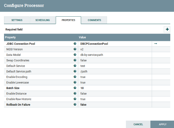
NGSIToCarto is configured through the following parameters (Parameters in bold are required):
| Name | Default value | Allowable values | Description |
|---|---|---|---|
| JDBC Connection Pool | No | Controller service for connecting to a specific database engine | |
| Data model | db-by_service-path | db-by_service-path, db-by-entity | The data model for creating tha tables and schemas |
| NGSI version | v2 | v2 | NGSI version you want to use |
| Default service | test | In case there is not Fiware-Service in the context broker, this value will be set | |
| Default service path | /path | In case there is not Fiware-ServicePath in the context broker, this value will be set | |
| Enable encoding | true | true, false | true enables the new encoding, false enables old encoding |
| Enable raw historic | true | true, false | true enables raw-based storing |
| Enable distance historic | false | true, false | true enables distance-based storing |
| Swap coordinates | false | true, false | true changes position between latitude and longitude |
| Enable lowercase | true | true, false | true for creating the Schema and Tables name with lowercase |
| Batch size | 10 | The preferred number of FlowFiles to put to the database in a single transaction | |
| Transaction timeout | no | 30 | Specify how errors are going to be handled. By default(false), if there is an error the FlowFile will be routed to "failure" or "retry". If it is enabled the failure FlowFiles will stay in the input relation without penalizing it and being processed repeatedly until it gets processed successfully or removed. |
An example of this configuration can be:
Important notes
About the encoding
Until version 1.2.0 (included), Draco applied a very simple encoding:
- All non alphanumeric characters were replaced by underscore,
_. - The underscore was used as concatenator character as well.
- The slash,
/, in the FIWARE service paths is ignored.
From version 1.3.0 (included), Draco applies this specific encoding tailored to PostgreSQL data structures:
- Lowercase alphanumeric characters are not encoded.
- Upercase alphanumeric characters are encoded.
- Numeric characters are not encoded.
- Underscore character,
_, is not encoded. - Equals character,
=, is encoded asxffff. - All other characters, including the slash in the FIWARE service paths, are encoded as a
xcharacter followed by the Unicode of the character. - User defined strings composed of a
xcharacter and a Unicode are encoded asxxfollowed by the Unicode. xffffis used as concatenator character.
Despite the old encoding will be deprecated in the future, it is possible to switch the encoding type through the
enable_encoding parameter as explained in the configuration section.
About the distance-based storing
In case that enable_distance is enabled and the table of the database is empty, the values of the parameters
stageDistance, stageTime, stageSpeed, sumDistance, sumTime,sumSpeed,sumDistance2, sumTime2 and
sumSpeed2 are set by default to 0 and the values of maxDistance,minDistance, maxTime,minTime,maxSpeed and
minSpeed are set to infinity in the case of minimum values and in the other case to -infinity.
If the table is not empty, the calculations of distance, speed and time will be done.
EPSG system reference
Parameters the_geom and the_geom_webmercator use a system reference EPSG, that is a code in order to be read by
Carto. In case of the_geom EPSG 4326 is the horiontal component for a 3D system , it is used by the nagevation system
GPS. In the case of the_geom_webmercator, is used EPSG 3857 useful for the creation of web maps.